Overview
For small satellites such as CYGNSS, the propulsion can represent a significant proportion of the mission cost, in which cases passive techniques must be implemented. In the case of CYGNSS, atmospheric drag is used to control the trajectories.
Historical and real time spacing - Animation
Animation 1 shows a daily animation of the CYGNSS positions along the orbit with respect to FM03 and their altitudes since launch. In the top plot, high drag maneuvers are labeled as "HD" and Sun pointed attitude configurations as "SP". During such maneuvers, the altitude drops faster (bottom right) and the angular spacing with FM03 increases less fast (bottom left). Early September 2017, a strong geomagnetic storm hit the Earth and caused a sudden increase in drag, resulting in a faster drop of CYGNSS altitudes.
Hit Play!
What is drag?
To understand what drag is, imagine you're in a car and you put your hand outside (as a passenger...). You'll feel the force of air pushing your hand backwards, in the direction opposite to the motion of the car: that's atmospheric drag. Atmospheric drag is the result of collisions between air molecules and a surface in motion (in this case, your hand). Anywhere where there is air, there is drag. Drag depends on the density of the air (the more dense, the more drag), on the area of the surface (put the entire arm outside and you'll feel more drag than if you only put the hand), on the speed of the object (if the car goes faster, it'll be harder to keep your hand straight), on the mass of the object (heavier objects are less sensitive to drag), and on the properties of the surface of the object (through a coefficient, called the drag coefficient).
Effects of drag on satellites
As the altitude increases, the density of the air decreases significantly. At 500 km, where the CYGNSS satellites orbit, the atmospheric density is about 10,000 billion times smaller than at sea level. However, even if the air is very thin, it still creates drag. As a result, satellites lose energy and their altitude decrease. As the altitude decreases, the satellites speed increase (objects in orbit at low altitudes move faster than objects at high altitudes). In other words, drag changes the position and the velocity of satellites.
The issue is that drag is really hard to accurately predict. The main reason is that the atmospheric density and the drag coefficient are both very complex to model. Consequently, there are errors associated with the predictions of satellite trajectories. For satellites orbiting below ~1,000 km (in "low orbit"), drag is the largest source of errors. This can have important consequences on the mission, particularly for collision avoidance. In addition, since drag causes satellites in low orbit to lose altitude, they end up reentering the Earth's atmosphere and burning up on re-entry. Predicting the long-term effects of drag is thus a crucial component of space mission design.
Using drag to control CYGNSS trajectories
Due to the effects of drag, a high drag maneuver can be used to control the trajectory of the CYGNSS satellites. There are two main situations for which such maneuvers are carried out: to change the spacing between the observatories and to avoid collisions with debris or other orbiting spacecraft (discussed here).
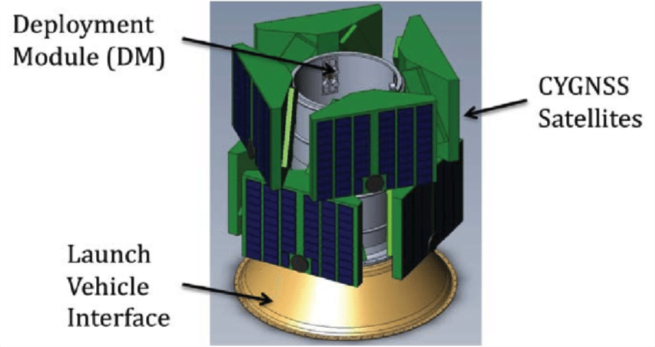
The CYGNSS satellites were injected into orbit from the deployment module shown in Figure 1 (Finley et. al, 2013). The deployment module was moving at ~7.5 km/s and released each CYGNSS in a different direction with a speed of ~0.6 m/s.
The differences in the direction of deployment introduced differences in the semi-major axis (size of the ellipse of the orbit) of each CYGNSS's orbit, hence in the orbital speed: the highest semi-major axis (lowest speed) for the satellite deployed in the direction of motion of the deployment module (CYGNSS FM01), and the lowest semi-major axis (highest speed) for the satellite deployed in the direction opposite to the motion of the deployment module (CYGNSS FM03). This is shown in Animation 1 (top), where the circle represents the orbit of the CYGNSS satellites. Each dot represents the position of a CYGNSS with respect to FM03, which thus look still. After deployment, each satellite starts to lag behind FM03, the fastest satellite. The spacing between each CYGNSS increases due to the differences in orbital speed. If no maneuver was performed, the satellites would freely drift away from each other and eventually lap each other. However, to maximize the coverage of tropical cyclones, the CYGNSS satellites are required to be evenly spaced out along the orbit.
To control the spacing, differential drag maneuvers are thus carried out, labeled as "HD" in the animation. For example, 4 high drag maneuver were performed on FM06 in 2017: May 4 to 16, June 6 to 14, October 17 to 31, and December 12 to 14. When pitched into a high drag configuration, the increase in drag caused FM06 to lose altitude and gain speed. As a result, its semi-major axis decreases faster (Animation 1, right plot) and its spacing with respect to FM03 continued to increase but at a slower rate (Animation 1, left plot). After the 4th and last high drag maneuver, FM06 reached its final position in the orbit plane, ~140° from CYGNSS FM03. As of now, 4 CYGNSS have reached their final position: FM03, FM04, FM06, and FM07. High drag maneuvers will continue to be carried out on FM01, FM02, FM05, and FM08 until the final configuration is obtained: 8 CYGNSS evenly spaced out along the orbit.